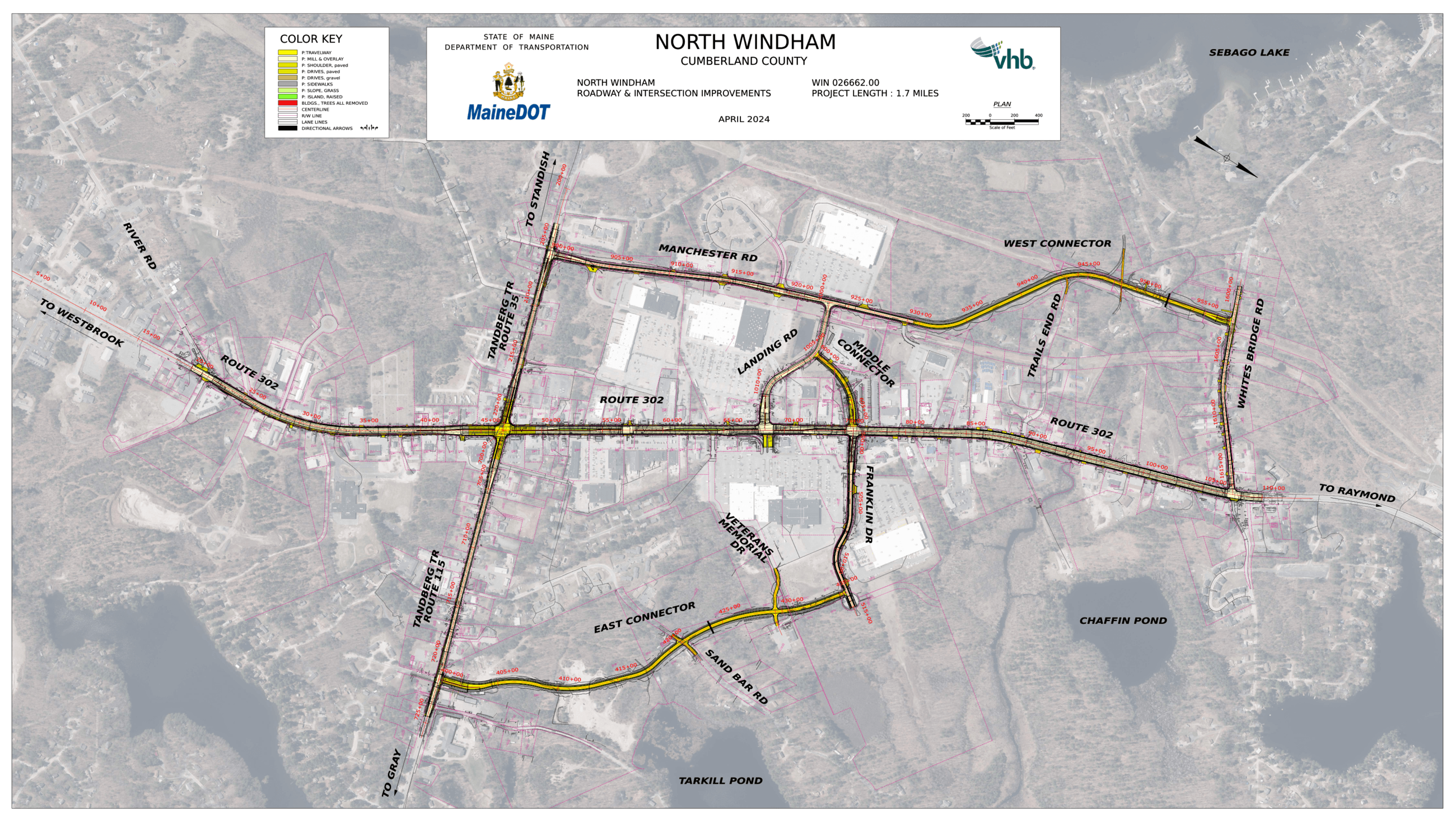
North Windham Moves Conceptual Improvements Plan showing the proposed Route 302 corridor improvements and connector road network.
Source: Town of Windham, North Windham Moves project documents. Concept plan by VHB (Vanasse Hangen Brustlin, Inc.) for Gorrill Palmer. Reproduced from official municipal planning documents.
Route 302 Is Changing
Here's What's Planned—and Why It Took Decades to Get Here.
Windham's Route 302 fix is funded and scheduled — and the public record shows it took 35 years of planning to get there.
MaineDOT and Windham are building three new connector roads behind the commercial strip, along with roadway and intersection improvements at Routes 302, 35, and 115, and new adaptive traffic signals. The project totals $31.25 million, including $25 million in federal funding, with construction scheduled for 2027 through 2030.
The public record shows this plan didn't begin with the 2023 grant — documented planning for this stretch stretches back to 1988, three and a half decades before funding arrived. The publicly accessible record we located for Naples' Route 302 corridor tells a less complete story, leaving important questions this investigation will continue to examine.
Executive Overview
Route 302 does double duty through North Windham: a local street lined with businesses, and a regional highway carrying through-traffic toward the rest of the Lake Region. The connector roads — part of the North Windham Moves project — are designed to separate those functions, letting local trips use new streets behind the commercial strip instead of merging onto Route 302 for every errand. According to the project's traffic modeling, the connector-road network is intended to move many short local trips off Route 302 so the highway can function more efficiently as the region's primary travel corridor. The 2022 feasibility study that shaped the final design projected this separation would reduce traffic on the affected stretch by approximately 34% — a projection tied to that study, not a guaranteed outcome. That plan has a longer history than its 2023 funding announcement suggests. Public records document a sustained planning effort in Windham stretching from a 1988 corridor study through more than a dozen subsequent documented planning actions. Naples, home to the corridor's other well-known bottleneck at the Causeway, doesn't yet show a comparable planning record in the publicly accessible sources reviewed for this investigation. That's not a verdict — MaineDOT's own materials separately credit Naples with past corridor-partnership success, and a Naples planning update now underway wasn't accessible for this review. What this investigation continues to track is which corridor communities are building the kind of documented record that eventually becomes a funded project — and which remain earlier in that process than the public record currently shows.
What Changed?
Windham's long-planned Route 302 improvements have moved from years of planning into a funded construction program. Backed by a $25 million federal RAISE grant as part of a $31.25 million project, the corridor is now scheduled for major improvements beginning in 2027. The change isn't simply that funding arrived—it's that decades of documented planning have reached the point where implementation can begin, offering a rare opportunity to examine how long-term transportation planning becomes a built project.
Historical Context
The public record traces today's project back more than three decades. Beginning with transportation studies in the late 1980s, followed by regional planning efforts, corridor studies, local policy decisions, engineering work, and years of public engagement, Windham steadily developed the documentation that ultimately supported federal investment. This investigation follows that timeline not to revisit history, but to understand how sustained planning shaped today's project.
Current Conditions
Construction has not yet begun, but the project has moved beyond concept. Funding has been secured, preliminary engineering and design work have been completed, and construction is scheduled between 2027 and 2030. Along the rest of the Route 302 corridor, communities continue addressing transportation challenges through their own planning processes, creating an opportunity to compare how different approaches to long-term planning may influence future infrastructure investment.
Why It Matters
Why It Matters
Major transportation projects shape far more than travel times. They influence how communities grow, where businesses invest, how residents access housing and services, and how effectively regions compete for future infrastructure funding. The Route 302 project illustrates that solving long-standing transportation challenges often requires years of documented planning before construction ever begins.Infrastructure Impact
The Windham project demonstrates how transportation infrastructure evolves through a long-term process of planning, engineering, public engagement, and investment. Beyond improving one section of Route 302, the project provides a documented example of how sustained planning can position a community to compete for major infrastructure funding. As other Lake Region communities continue addressing their own transportation challenges, the public record offers an opportunity to compare how different planning efforts develop over time.Professional Perspectives
Housing
Transportation and housing are increasingly linked. As residential growth continues across the Lake Region, the ability of major corridors like Route 302 to move people efficiently will influence where new housing is built, how quickly communities can support growth, and how residents experience daily travel. Long-term transportation planning is becoming an increasingly important part of long-term housing planning.
Development
Major infrastructure projects rarely appear overnight. The Windham project illustrates how years of planning, engineering, public engagement, and funding preparation can shape future development opportunities. For developers, builders, and investors, understanding where communities are building long-term transportation capacity may provide valuable context for evaluating future growth patterns across the Lake Region.
Construction
Large transportation projects create work long before construction begins. Engineering, utilities, surveying, site preparation, paving, traffic systems, landscaping, and supporting trades all play a role as projects move from planning into implementation. For contractors, understanding where infrastructure investment is progressing can provide valuable insight into future bidding and business opportunities.
Tourism
Route 302 is one of the Lake Region's primary gateways for visitors. Seasonal congestion affects travel times, visitor experience, and access to local businesses, attractions, and waterfront communities. Transportation improvements are intended not only to improve mobility for residents, but also to help maintain the region's accessibility during its busiest tourism seasons.
Emergency Response
Traffic congestion affects more than convenience. Police, fire, and emergency medical services rely on dependable travel times when responding to incidents along heavily traveled corridors. While this investigation does not evaluate emergency response performance, it highlights how transportation planning can influence the reliability of critical public services over time.
Municipal Planning
Windham's experience illustrates that major infrastructure funding is often built through years of documented planning, engineering, public engagement, and interagency coordination. For municipal leaders, the investigation suggests that maintaining a consistent public planning record may strengthen a community's readiness for future transportation investment opportunities.
Regional Economy
Transportation corridors support far more than vehicle traffic. They connect employees to jobs, customers to businesses, contractors to projects, and visitors to local destinations. As the Lake Region continues to grow, the long-term performance of Route 302 will increasingly influence economic activity throughout the region, making transportation planning an important component of broader regional development.
Verified Sources
Municipal
Official records from the Towns of Windham and Naples, including Comprehensive Plans, Planning Board materials, Town Council and Select Board records, capital planning documents, transportation planning files, and other publicly available municipal documents reviewed during this investigation.
County
Regional planning materials and supporting documentation prepared by the Greater Portland Council of Governments (GPCOG) and other regional planning organizations contributing to transportation and corridor planning within Cumberland County.
State
Maine Department of Transportation (MaineDOT) corridor studies, Route 302 planning documents, feasibility studies, project updates, transportation planning reports, engineering materials, public meeting documentation, and official project information.
Federal
U.S. Department of Transportation RAISE Grant documentation, Federal Highway Administration program information, federal transportation funding records, and publicly available grant materials supporting the Windham Route 302 project.
Primary Documents
Original planning studies, transportation reports, Comprehensive Plans, engineering documents, public meeting records, grant documentation, official maps, and other primary-source materials reviewed directly during this investigation whenever publicly accessible.
Maps & GIS
Official mapping resources, municipal GIS systems, MaineDOT mapping tools, transportation corridor maps, aerial imagery, and publicly available geographic information used to verify locations, transportation features, and project context.
Intelligence Assessment
What Changed Since Last Issue
This investigation begins with Issue 002. Future issues will track verified developments, planning actions, funding decisions, design updates, construction milestones, and other publicly documented changes affecting the Route 302 corridor.
A New Investigation Begins
Throughout this investigation, another question repeatedly surfaced. While North Windham's transportation planning is documented through years of studies, engineering plans, and public records, the Route 302 Causeway in Naples presents a very different public record. Rather than speculate, we chose to continue the reporting. That investigation is now underway and will become the focus of Issue 003.
Supporting Investigations
Regional Development Watch
Transportation planning and regional growth continue to influence one another across the Lake Region. This investigation monitors publicly documented development activity, infrastructure investment, and planning decisions that may shape future housing, business, and transportation patterns.
Why It Matters
No community develops in isolation. Housing, commercial growth, transportation improvements, and public investment often extend beyond municipal boundaries, creating regional effects that influence residents, businesses, and local governments alike. Monitoring these connected trends helps identify emerging patterns before they become obvious.Infrastructure Impact
Major transportation projects can influence where future growth occurs, while continued development increases demand for additional infrastructure. Tracking both together provides a clearer understanding of how the Lake Region is changing and where future planning efforts may emerge.Status: ACTIVE — Ongoing Regional Monitoring · Next: Continue tracking publicly documented development proposals, transportation planning, infrastructure funding, housing activity, and municipal planning actions throughout the Route 302 corridor and the broader Lake Region.
Today's planning agendas, permit activity, and public hearings often become tomorrow's construction projects. This section monitors verified public actions that may influence future development, infrastructure, and investment across the Lake Region.
Why It Matters
Planning Board agendas, municipal permits, zoning decisions, and capital planning actions provide some of the earliest public signals of future change. Following these records helps identify emerging trends before projects become visible on the ground.Infrastructure Impact
Transportation improvements, utility expansions, subdivision approvals, commercial permits, and municipal capital projects frequently develop together over time. Monitoring these public actions provides a clearer picture of how infrastructure investment and community growth are evolving across the region.Status: ACTIVE — Ongoing Public Record Monitoring · Next: Continue reviewing Planning Board agendas, Select Board and Town Council actions, permit activity, comprehensive planning updates, zoning amendments, and publicly announced infrastructure proposals throughout the Lake Region.
Construction Activity
Years of planning are beginning to turn into visible construction. This section tracks what's funded, what's scheduled, and the changes residents, businesses, and commuters can expect as the Route 302 corridor enters its next phase.
Why It Matters
Route 302 is more than a traffic corridor—it is the Lake Region's primary connection for residents, businesses, tourism, and emergency services. As growth continues, the ability to move from recognizing congestion to funding long-term improvements will increasingly influence housing, economic development, and public investment across the region.Contractor Impact
The Windham project signals years of transportation-related construction activity ahead, including roadway improvements, utility coordination, traffic management, and supporting infrastructure. Contractors across multiple trades should monitor project milestones and future bid opportunities as the project advances toward construction.What We'll Continue Monitoring
State & Regional Agency Studies
New MaineDOT corridor studies, regional transportation planning efforts, engineering updates, and other publicly released agency reports affecting Route 302 and the broader Lake Region transportation network.
Transportation & Mobility Indicators
Traffic counts, travel-time trends, intersection performance, congestion studies, seasonal travel patterns, and other publicly available transportation data that help measure how conditions change over time.
Planning Board Agendas
Planning Board agendas, workshop discussions, subdivision reviews, site plan applications, zoning proposals, and other public actions that may influence future development and infrastructure needs.
Select Board Discussions
Transportation priorities, capital improvement planning, Comprehensive Plan implementation, infrastructure funding discussions, and other public policy decisions affecting corridor development.
Infrastructure Funding
Federal, state, regional, and local funding opportunities, grant awards, capital improvement programs, and transportation investments that may influence future infrastructure projects throughout the Lake Region.
Development Proposals
New residential, commercial, mixed-use, and institutional development proposals that could affect traffic demand, infrastructure capacity, and long-term regional growth patterns.
Subdivision Approvals
Major subdivision applications, approvals, amendments, and construction activity that may contribute to future transportation demand and community growth.
Emergency Response Planning
Publicly documented emergency management planning, transportation resiliency initiatives, evacuation planning, and roadway access improvements that may affect public safety and emergency response capabilities.
Regional Growth Indicators
Verified public signals including building permits, utility extensions, municipal capital projects, land-use changes, housing activity, commercial investment, and other measurable indicators of long-term regional growth.